Cruising & Moorings


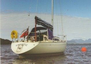
Off to the pub at Arisaig - photo by Bruce Benson
Comprehensive information on cruising destinations may be obained via the Welcome Anchorages and MalinWaters websites.
Via the Clyde Moorings Committee, the Association is involved in the process for approving moorings and other floating structures within the Clydeport area. The West Highland Anchorages and Moorings Association ( WHAM ) coordinates these activities external to the Clyde.
The Association encourages Clubs to obtain mooring licences from The Crown Estate for moorings areas, thereby ensuring a measure of protection against commercial encroachment. Significant discounts are available for Group Moorings as opposed to individual applications. Access is provided below to an Association newsletter from 2006 with more information on club mooring areas.
Applications should be made using the Moorings Application Form which can be downloaded from The Crown Estate website.
Boat owners who are unsure where their preferred Moorings Association might be, or who need advice on the process and on how to find a moorings contractor, can contact John Kent at Bidwells who manage Crown Estate Scotland business:
- email: john.kent@bidwells.co.uk
- mobile: 07525 235888
RYA Scotland also maintains a keen interest in protecting yachtsmen's interests at the same time as recognising that commerce must not be stifled by narrow sectoral attitudes.
Within the "greater Clyde" and in conjunction with The Crown Estate, Clydeport and QHM, the Association has been involved in categorising traditional anchorages to ensure that appropriate areas are maintained free of moorings or other structures to allow anchoring. This exercise was last conducted in February 2011 and this page links to a map showing recognised Protected Anchorages within the Clyde estuary and sea-lochs. Details will added progressively to illustrate these locations.
Skippers should bear in mind that this map is illustrative and is not intended for navigation. Proper navigational aids must be used, and buoyage and/or perches observed at all times
The Association's 2004 Yearbook contained an item on the navigational care that needs to be taken by deeper draft (2m or more) vessels using the "South Channel" between Bute and the Burnt Isles north of Colintraive. This item has proven to be of recurring interest and is re-published here. Note however that the more southerly starboard-hand buoy was replaced in October 2014 by a North Cardinal beacon bolted on to the NE extremity of Woodfarm Rock, and the buoy was removed. This initiative was funded by the CYCA via significant contributions primarily courtesy of GSS Marine, McNair Engineering, and member clubs.


